
We went to Wales again! North Wales, this time. And we started our visit by going up Snowdon, the highest mountain in Wales.
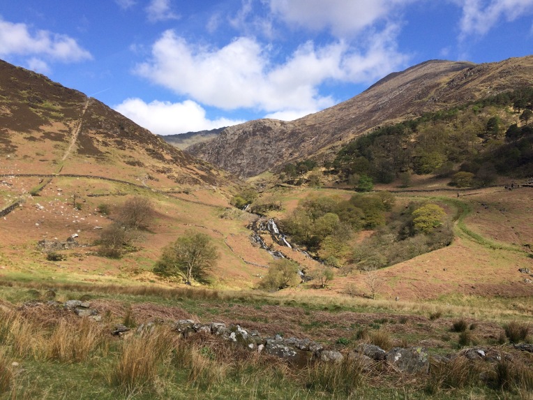
This was our view when we got out of the woodland in the valley and up the slope of the mountain. Snowdon’s top is out of sight on the right. This waterfall was absolutely gorgeous. I don’t know what it is; perhaps my Dutch heritage, but I always get so excited by water *grin*

This was the view from up the waterfall. Snowdonia is such an impressive national park.

We were so lucky, the weather was fantastic. Most of the way we could walk in a t-shirt. We even had a view from the top – most of the time it’s just clouds and mist! Our dog really needed the little brooks we came across for regular drinks.

That’s the actual top of Snowdon! The little path you can see twisting up to the top is just as scary as it looks. It’s basically just scrambling through loose debris for way too long. I was so scared the dog might slip and fall down the slope, but she was steadier on her feet than I was.

Closer to the top we began to meet more hikers. It’s funny to see how many people hike in England, even when they’re not specifically outdoorsy people. There was an easier way up, though. We started on the south side and walked up about a thousand meters. On the north side, you can drive up to a parking spot so you don’t have to climb all the way. There’s even a train and a café, though it wasn’t open. A shame, though, it sort of ruins the whole idea of having walked and climbed all the way to the top when you could’ve just taken the train.

Pretty dog enjoying the view… or wait, me enjoying the view of my pretty dog.

On our way down, we stopped for a break in the waterfall, and put our feet in the icy cold spring water. The dog agreed that the waterfall made for a very peaceful resting place and decided to go for a nap.

As you can see, I need to practice my panoramic pictures a bit more… a view of Snowdon with a bit of Irish Sea in the background.
When one is in North Wales, what better to do than hike? So a couple of days later (we also wanted to visit some lovely old towns) we went up Yr Eifl. This group of mountains is not nearly as high as Snowdon, but it’s right on the edge of the sea, and the weather was a lot more severe this day.
At first we walked (and scrambled the last bit) up to Garn Ganol, the highest top of the three. The loose boulders you can see on the right of this picture are part of the cairn on top of the mountain. The top on the left is Garn For, the lowest of the three tops. Behind it the Irish sea.

And if you look the other way, you see Tre’r Ceiri. This top is crowned with an amazing iron age hillfort. Garn Ganol allows you a perfect view of the dry stone walls and if you look closer the stone circles that made up the housing for these people.

We went down from Garn Ganol and up Tre’r Ceiri. This is the view from below. You can see the dry stone walls quite clearly among the debris it was made up off. On the right you can see the ‘hole in the wall’ that was the entrance of the actual fort. The outer wall, which is below the actual fort, was likely an enclosure for animals.


I was so impressed with the hut circles, or in this case rectangulars. These walls are also dry stone, although they might have at some point been closed off with mud. The dry stone walls that encircle the fort are impressively wide: you can see part of it on the right of the picture. They keep out the wind perfectly well. I was amazed by how well preserved these were. Though archeologists have been cleaning up the area a bit to make sure the hillfort will last another thousand years or more…

This is the view from Tre’r Ceiri up Garn Ganol. The path we walked is quite clearly visible, as is a smaller dry stone wall crossing the little moor. I’m pretty sure there has also been a manmade structure on the left part of the picture, but I couldn’t gather what it might have been. It’s both exhilerating and frustrating that the British leave all their wonderful archeological history just lying around where you can stumble across it without really knowing what it is.

Another hut circle with a view at the fortress wall. From inside the fort the wall isn’t very tall, but when you’re on top of the wall and look down, you can imagine that enemy people would have had a lot of trouble trying to get into the fort. I always love how people managed to build anything they needed from very local materials. Here the granite has been used in everything from stone circles to churches to modern houses. Us Dutchies didn’t have proper stone to build things from, so we decided to bake our clay into stones and used water reeds for thatching.

There is a cairn in the hillfort and this is the view down from that point. You can see how the hut circles are all attached to eachother, either directly or via a wall that must have closed off yards for working in or perhaps keeping smaller animals, growing certain plants, et cetera.

Afterwards we walked all the way down the mountains to the coast, to the old quarry of Nant Gwrtheyrn. This place is now a language learning centre but it used to be the village Porth y Nant, which was abandoned when the quarry shut down.

Here we enjoyed our first bit of proper Welsh pebble beach and sea. Then we had to scramble back up the hill to the parking place to find our car.
The next day (or the day after) we decided to discover a bit more of the Llyn Peninsula. We drove all the way up to the end, where we parked our car in Aberdaron to do do a decent part of the Welsh Coastal Path.

Ah, spring time in Wales. The landscape was so beautiful!

As is Kim! Ah, sorry, proud dog mum. Behind her you can view Bardsey Island, where pilgrims used to travel to. Apparently, twenty thousand saints were buried here. I didn’t know there had even been so many saints, but oh well, they apparently all went here.
We didn’t go there, for lack of a boat (or a ticket for one). But we did enjoy some spectacular coastlines. Oh man, I love the Welsh coasts. The rugged rocks, the beautiful sloping hills, the blue blue sea…

Still didn’t see any seals, though 😦

Some of these coastal hills can be quite steep!

Doesn’t that make you want to discover every cranny and nook of those rocks? There might be caves..!

See? Actual caves! The dog refused to go in, but we quite enjoyed scrambling around here. My camera can’t deal with the darkness, unfortunately, but there was a little spring in the cave that showed us quite neatly how this cave had been carved out in the rocks over tens of thousands of years.

And besides those wonderful rocky coasts there are also beaches… Okay, to be fair, most British beaches aren’t very impressive compared to our broad, Dutch, sandy beaches. But this one gave it a decent try!

The sunlight captured the castle in the back perfectly… That’s Criccieth Castle, by the way. And the picture is askew, bad Friggja…
We went to more wonderful places, but I have to stop at some point. Safe to say we have hardly seen anything yet: North Wales is filled to the brim with wonderful places to hike, climb and do various outdoorsy things, *and* there’s the amazing historical and prehistorical features you find literally everywhere. I want to go back!

Wat hebben jullie een prachtige reis gemaakt!
LikeLiked by 1 person
Jaaa. Volgende keer moet je mee!
LikeLike
Wow wat is het mooi daar!
LikeLike
Ja echt super. Ben verliefd!
LikeLike
Prachtige foto’s. Ik ben jaloers want ik wil ook, haha! 😀
LikeLike